Our Changing Earth
THE LIFE SPAN OF a human is only a freeze frame in the video of the earth in geologic time. The earth is so old and most geologic processes so slow, that we don't notice the changes around us. If it wasn't for volcanos and earthquakes, we might think that the land never changed.
But the land does change, and even move! The crust, or the solid shell of the earth is about 25 miles thick over the continents, and about 4 miles thick under the ocean floors. The crust of the earth is thought to be made of semi-rigid plates that float on the plastic (here we use the word "plastic" to mean it flows under long term pressure) mantle of the earth. The movement of the plates is considered as the Plate Tectonic Theory.
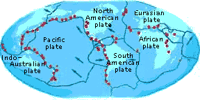
Diagram of the earth's major tectonic plates, showing locations of volcanoes. Tectonic forces, volcanoes and earthquakes all occur together and are interrelated.
Spreading
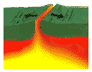 Where two plates spread apart, cracks or rifts form in the earth's crust. We see this force at work today in Iceland, where that island nation (and all of the middle of the Atlantic ocean) is spreading apart, and volcanoes are filling in the cracks with lava. Volcanoes make new land. Rifts on continents can create valleys, as is seen in the East African Rift Valley. The Atlantic ocean is spreading about 3/4ths of an inch per year. Not much you say? But it means that in your lifetime, North American will move westward the length of a man's body.
Subduction
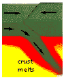 When two plates move toward each other, the denser one is forced under the other in a process called subduction. Deep trenches are formed when subduction happens in the ocean, also it gives rise to earthquake activity and volcanic islands. Japan is such a place, in the Pacific Ring of Fire. On land, continents colliding cause the land to raise up, (geologists call it uplifting) and this force can build mountain ranges. Right now, India is colliding with the Eurasian Plate, causing the Himalayan Mountains. The Andes mountains of South America are the result of the partial melting of the plate being subducted, with the resultant molten rock (magma) rising through the continental crust and building a distinctive mountain chain down the length of that continent.
Plates may also slide past each other, like what is happening in the western United States. The San Andreas fault in California is where the Pacific plate slides past the North American plate.
Continental Drift
Plate tectonics helps explain the theory of Continental Drift. That theory states about 175 million years ago all the continents of the earth moved together in a single giant landmass. Scientists have looked for evidence to support the idea that the land was once joined, and use several factors in their studies. If land once was joined, the rocks should share common characteristics across the original divide. As old as the earth is, chances are that the continents have all bumped into each other many times. Some scientists believe that the land masses have come together more than once.
In reconstructing the ancient world, it takes more than just fitting coastlines like pieces of a puzzle. It is better to fit the continents together not at the coast where active processes are changing the landscape, but instead at the continental shelf, which extends into the ocean, and then has a sharp drop to the ocean floor. The "best fit" is on the continental slope at about 1000 meters depth in the ocean. The best examples of continents fitting together are the east coast of Brazil in South America, and the southwest coast of Africa. Matches have been made not only in shape (only 1 percent mismatch at the continental shelf! ), but more importantly in the rock types, the fossils in the rocks, in radioactive dating of the age of the rocks, and by use of paleomagnetism in the patterns of the lava extruded from the mid-ocean ridges.
Paleomagnetism is a fascinating remainder of magnetic traces preserved in rocks. Iron minerals in volcanic or molten rocks will line up in the direction of the earth's prevailing magnetic field, and when the rock cools, the particles are fixed permanently like tiny compass needles in the rock. That means the magnetism in a rock today can pinpoint the earth's magnetic pole at the time that rock formed. The earth's magnetic poles have reversed themselves many times in the past 175 million years!
The evidence demonstates that the east margin of South America and west margin of Africa were once joined. The time when changes appeared in the rock sequence between South America and Africa gives a date when the Atlantic Ocean initially opened up.
Another clue to the changing positions of the land comes from fossil remains. Tropical fossils have been found in areas that are now in an arctic climate!
So what does all this have to do with Arkansas? Read on to find out about the continent that bashed up our mountains, and the continental crack at New Madrid!